

Spaldwick, Catworth, Leighton Bromswold
Introduction:
On a Shaw’s Stroll you are always guaranteed a good pub, and occasionally two, but this time I have surpassed myself – three excellent pubs, so two breaks along the way. You can start this circular walk at any of the three pubs – I chose to start at Spaldwick.
Spaldwick is an attractive village centred around its Green and is particularly noted for the period houses in the High Street and the bridge which carries the Thrapston Road over the brook dates from the 15th Century. The village is dominated by the church whose spire soars to 152 feet. Another feature of the church is its ornate Norman north doorway.
Catworth is a pleasant and quiet village with winding streets and varied architecture standing on a hill south of the A14 surrounded by farmland. Its 13th Century church, St. Leonards, has an octagonal spire and contains a monument to Rose Dryden, sister of the poet.
Leighton Bromswold is a charming and compact little village. Two features are of interest here - the moated gatehouse and the church. The former dates from the 15th Century and is the only part ever built of a great mansion designed by John Thorpe for the Duke of Lennox. The church is certainly one of the finest in the county, of striking early English design but after falling into near ruin was rebuilt in 1634 when the tower was added. The splendid furnishings of this period include the pulpit and reader’s desk.
Distance:16.3 km (10.3 miles). The walk can be completed in around 4 hours allowing for stops at the two pubs on route.
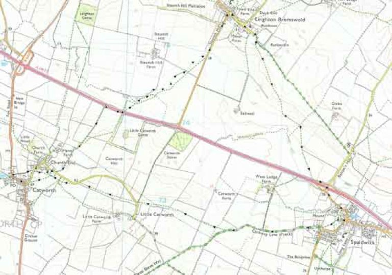
Map: OS Landranger sheet 153 Bedford, Huntingdon and OS Explorer sheet 225.
How to get there:Spaldwick lies off the A14 road between Huntingdon and Thrapston, approximately 5 miles west of the A1/A14 interchange.
Parking:The pub has ample parking at the front and the back.
Image produced from the Ordnance Survey Get-a-map service. Image reproduced with kind permission of Ordnance Survey and Ordnance Survey of Northern Ireland.
The Walk:
 From the George cross the green and walk up Church Lane. Passing by the left hand side of the church, note the fine decorated Norman porch, and then pass through a kissing gate, and cross the field to the opposite corner, pass through another gate. Turn right into Mount Pleasant.
Pass through a gate onto a track, following the sign for the Three Shires Way. Follow this track (known as Cockway Lane) with excellent views of the valley on both sides. At the yellow way marker, pass through the gap in the trees and cross a footbridge over a stream.
Pass along the right hand edge of the field. Cross a track and a stile at a yellow way marker. Continue along the edge of the field, beside a ditch. Cross another stile at a gate, and cross the ditch and continue along the right hand side of the ditch. Cross a stile and continue on the left hand side of the field. At the edge of the field, turn left onto a track. At the road, turn right, and in 100m turn left onto a marked footpath.
Cross the field, climbing the hill, heading for some trees, where you will cross a stile. Follow the left hand side of the field. At the next stile, look back and enjoy the view at the brow of the hill.
Continue through the next field, at the gate cross the stile, turn left along the road, and then pass through the hedge onto the marked footpath.
The path crosses the field going up the rise to a kissing gate in the opposite hedge. Note that this field may be ploughed. Cross the next field, heading towards the church, and through another kissing gate. Now cross the field, heading for the thatched house. Go through the kissing gate, turn left up the lane and right into Catworth High Street, and in 200m you’ll arrive at the Racehorse for a well earned break.
Leaving the Racehorse, turn down Fox Road, and then turn right on to a footpath between two houses. The footpath meets a road with the church opposite. Cross and pass through the kissing gate to the right of the churchyard. Following the left hand field edge, then crossing the field towards some trees, pass through a kissing gate on the left (yellow way marker), and go down a path between two houses.
At the road, turn right. After 200m, turn left onto a marked footpath, following a broad grass track on the left hand side of the field. Follow the track round a small thicket and down the slope towards the A14. At the A14, turn right, past the lay-by, and after 200m, cross the A14 where there is a break in the central reservation. Then continue in the same direction on the opposite side of the A14 for 100m, and then go down some steps and across a stile.
Turn half right taking the footpath across the field. The field has been ploughed, obscuring the line of the path, but if you head towards the church on the sky line you’ll be OK. After crossing the field, join the track at the field edge, with the tree line to your left. Officially the footpath continues across the ploughed field but the track is easier walking. Crossing the track that leads to a farm, continue along the left side of the field.
At the road, turn left and climb Staunch Hill to the village of Leighton Bromswold, your second break at the Green Man.
Leaving the Green Man, turn right along The Avenue. At the church, continue straight along Church Lane. Continue past a gate onto a track, and after a turn to the right and a turn to the left, branch right off the track into a field.
Once again the farmer has kindly obscured the line of the public footpath through ploughing, so follow the line towards the distant Spaldwick church, your destination. At a field boundary, with a line of electricity poles, a yellow way-marker on a pole indicates the change in direction, following the field boundary, leading you to a line of trees and a bridge across a ditch.
Continue across the field with the line of the path now heading towards the right of the church, but more clearly marked by different vegetation. At the field boundary, you will see that the path crosses the field to the edge of the A14, and heads for some steps up the bank of the road. Climb these steps, but then turn left and walk along the roadside, up the slip road, and cross the A14 over the road bridge. The road continues round to the left and back to the George.
The Pubs: