

Everton and Gamlingay
Introduction:
The walk starts and ends at the Thornton Arms, Everton and offers a chance to visit the Cock, Gamlingay at the half way point.
The small village of Everton sits on top of the Greensands Ridge, with a fine church and some thatched cottages. The church is mentioned in Domesday, but this early church was rebuilt in the middle of the 12th century, as a chancel and an aisled nave, the greater part of which still exists. At the end of the 14th century, the tower, south porch and clearstory were built, and about 100 years later, the chancel arch was rebuilt. Everton is part of the old parish of Everton-cum-Tetworth that spans the Bedfordshire Cambridgeshire border.
Gamlingay's interesting name is Saxon and means Gamlin's Hae or Island, since at one time the village was surrounded by a marsh. In medieval times Gamlingay held three manors, one of which was acquired by Merton College, Oxford who own a lot of the local land. Must of the village today dates from after the Great Fire of 1660 that destroyed 76 houses.
Distance: 9.5 km (6 miles).
How to get there: Everton is 1 mile north east of Sandy. After passing through Sandy, turn left off the B1042 just after the station.
Parking: There is a car park behind the pub, but if it's full, the park in the cul-de-sac alongside the pub leading to the church.
Image produced from the Ordnance Survey Get-a-map service. Image reproduced with kind permission of Ordnance Survey and Ordnance Survey of Northern Ireland.
The Walk:
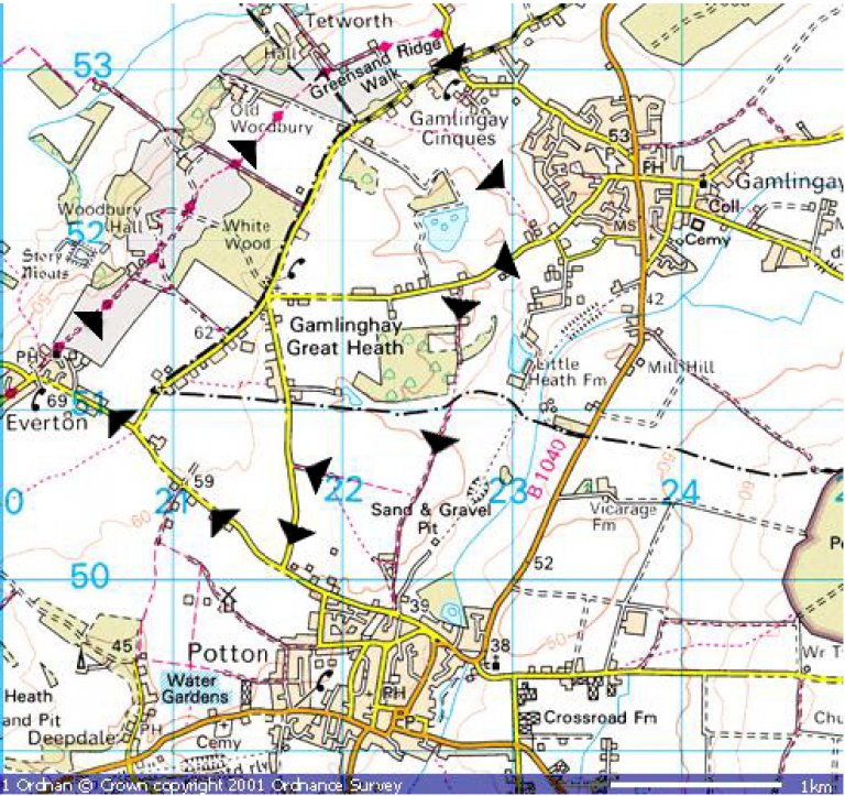 Walk down the cul-de-sac beside the pub towards St Mary's Church. From the church, follow the Greensands Ridge Way signpost, along an estate road through Woodbury Park Estate. Passing arable fields on both sides, walk towards woodland with views of the Bedfordshire countryside on the left. Pass through a gate past Storey Farm and continue on estate road. At the "cross roads" continue on towards Home Farm with Woodbury Hall on your left. Where the track bends to the left towards Home Farm, go straight through a kissing gate, and across a well-defined path across a field. At the hedge, go over a stile and turn right along an estate road for 100m, and then turn left to follow a path along the side of a field. Crossing another estate road, go through a gate and follow the way-sign across a meadow. After passing Tetworth Hall on the left, pass through a gate, walk across a field and join a track past an attractive thatched cottage on the right. When the track turns right, continue straight along left side of a field. At this point there are fine views of rolling countryside to the left. At the end of the field, pass through the gate to a road. This is the end of the Greensands Ridge Way.
Turn right long the road, and at the crossroads, go straight on towards Gamlingay. After 100m, just before the bend in the road, turn right along a marked footpath "The Clopton Way". Follow the track between two cottages, and continue along the track past a house on the right, continuing between a hedge and a fence. Reaching the edge of a field, with Sandy Heath Transmitter in front of you, turn left along an old track between fields and heath land (this track can be muddy).
At the end of the track, you have a choice. If you are ready for some refreshment, turn left along Heath Road, where the centre of Gamlingay is 600m away with a number of pubs, the Cock in Church Street being particularly recommended (more details below, and return to this point to continue the walk).
Turning right from the end of the track, follow the Heath Road back towards Everton, past the idyllic Mount Pleasant Farm on the left, until after 500m you turn left onto a track, signposted to Potton. Where this track bends to the right, cross the stile following the way-mark to follow a parallel track. As you enter woodland, cross a stile next to agate, and pause to take fine views across wooded countryside. Follow the right edge of the field, cross another stile and continue on to pass through a gate. Turn left and cross a stile and a plank bridge over a brook. Follow the right hand edge of the field in front, towards rising land. Where the line of trees ends, continue between two open fields. Passing to the right of a line of trees, and then a disused pit, you come to the edge of the large field. At this point turn right and follow the edge of the field. Continuing in the same direction for 650m will bring you to a road.
From this point, there is no easy route back to our starting point, other than via road, and since by now you will no doubt be developing a thirst for some good ale, a major detour would not be a good idea. Turn left and follow the road to a T-junction. Turn left onto the Everton-Potton road and walk the remaining 1-mile back to Everton.
The Pubs: