

Bythorn & Keyston
Introduction: This walk can start and end either at the Pheasant, Keyston or the White Hart, Bythorn.
Both Bythorn and Keyston have entries in the Doomsday Book. Bythorn was at that time owned by Ramsey Abbey. St Lawrence's Church dates back to the 12th century and has parts dating to the 13th - 16th centuries. It is noted for its lack of spire, replaced in 1960 with a hexagonal copper cap on a wooden frame. Keyston's name derives from Ketil's Stone, probably a boundary marker from 1,000 or more years ago. The church of St. John the Baptist dates from the 13th century and major reconstruction taking place in the 15th century. A manor house was built nearby in 1589 but now only earthworks remain. The current Manor Farm was built in 1835.
Distance:6.5 km (4 miles). The walk can be completed in less than 2 hours, excluding time for refreshments.
How to get there:From the A14 going from Huntingdon towards Kettering, take the B663 exit to the left to Keyston, or to the right to Bythorn.
Parking:Both the Pheasant and the White Hart have ample parking.
Image produced from the Ordnance Survey Get-a-map service. Image reproduced with kind permission of Ordnance Survey and Ordnance Survey of Northern Ireland.
The Walk:
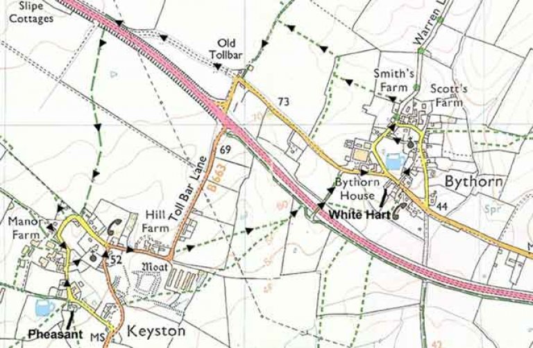 From the front of the Pheasant, Keyston, turn left and follow the road towards the church. In front of Manor Farm, with its elegant double bay windows, cross the road and take the footpath towards the church. The beautifully landscaped water gardens to your left were constructed in 1960 for an elderly lady living in the Manor House. Pass through the churchyard and through the church gate, turning left onto the road. Follow the road round to the right, passing a variety of stone buildings, some old, some new.
After the road takes a sharp left bend, take the marked footpath on the right. The path crosses a field and is poorly marked - head towards the church on the skyline. Pass over a footbridge across a brook, and cross another field - head for the dead tree next to another footbridge. Crossing a third field, head for a stile which leads to a concrete road. Turn right and in 30 metres, turn left over the road bridge. Continue along the concrete track and turn right at the road. After 300 metres you will see the White Hart, Bythorn. [Note: this pub is now closed] Leaving the White Hart, Bythorn, cross the road and go up School Lane, passing thatched cottages, an old school house and a church with an unusual spire. Immediately after the church, turn left onto a path. At the road, turn right, passing a row of old red brick cottages. After passing a farm yard on your left, take the marked footpath, passing between bushes and over the style. With the barn to your left, continue along the left hand field edge, and at the field boundary cross the style. Continue across the next field diagonally, to the right hand corner, and pass over a stile next to a metal gate. The path across the next field is poorly marked - aim for the barn on the skyline. Reaching the barn, join the track turning to your left, and continue until you reach the road and the Old Toll Bar House. Turn right, walking in front of the house along the road marked as a dead end. Pass to the left of the metal gate barring the road. Continue along the road, the old main road to Kettering, until you reach a bridleway sign and a gate on the left. Pass through, turn right, and very carefully cross the dual carriageway at the gap in the central reservation.
The bridleway continues on the other side of the road, straight across a field - aim in the direction of the church spire. When you reach the track in the middle of the field, head towards the barns to the right of the church. At the field edge, pass through the hedge behind a house with pink walls, go right along the back of the house, and passing into another field, turn left and follow the field edge. Turn right at the corner, and you will come to a gap in the hedge, where you will join a track, turning left. Follow the track with the farm barns on your right, and the line of fir trees on your left, until you reach the road. Turn right, passing Keyston church once again on your left and you will soon finish at the Pheasant.
The Pub: